
ASAP 14333: A Case for More ASAPs
By MS. ALLISON ELLIOTT, STAFF WRITER
During their approach into an airfield in Norway, an aircrew experienced an incident that spurred Capt Christopher Stewart to sit down with fellow crew members, Capts Rich Gangloff and Scott Strebel, SSgt Taylor Trapp, and SrA Josh Hicks, to write down information for a much-needed Airman Safety Action Program (ASAP) submission.
The crew members were in a C-17 on their way through the Scandinavian country to the Bardufoss Airport, which sits in a bowl and is surrounded by mountainous terrain. The pilots and crew had never landed at that airport before, so it was a new experience for all. Because of the pandemic, the pilots also had not flown for a while.
The weather was clear as they made their final approach, and they were able to clearly see the airfield from a distance. As they approached a large hill that slopes down to the runway, the Terrain Awareness and Warning System (TAWS) alerted them to terrain and obstacles ahead. TAWS forecasts where it thinks the plane is going to be and compares the location to the database (which includes towers and obstacles) it has from the terrain around the world. The pilots could see, however, that there were no obstacles in their way.
As the Aircraft Commander, Stewart decided to have the more experienced pilot onboard make the approach, and they landed without incident.
In reflecting on the incident, Stewart is thankful for the clear weather. “If we would have been in the weather and not able to see, yes, it would have been terrifying,†he said. Perhaps as an initial reaction, but Stewart and his professional crew would have simply gone around, as they and all C-17 crews are trained to do. At worst they would have been inconvenienced by having to divert to another airfield.
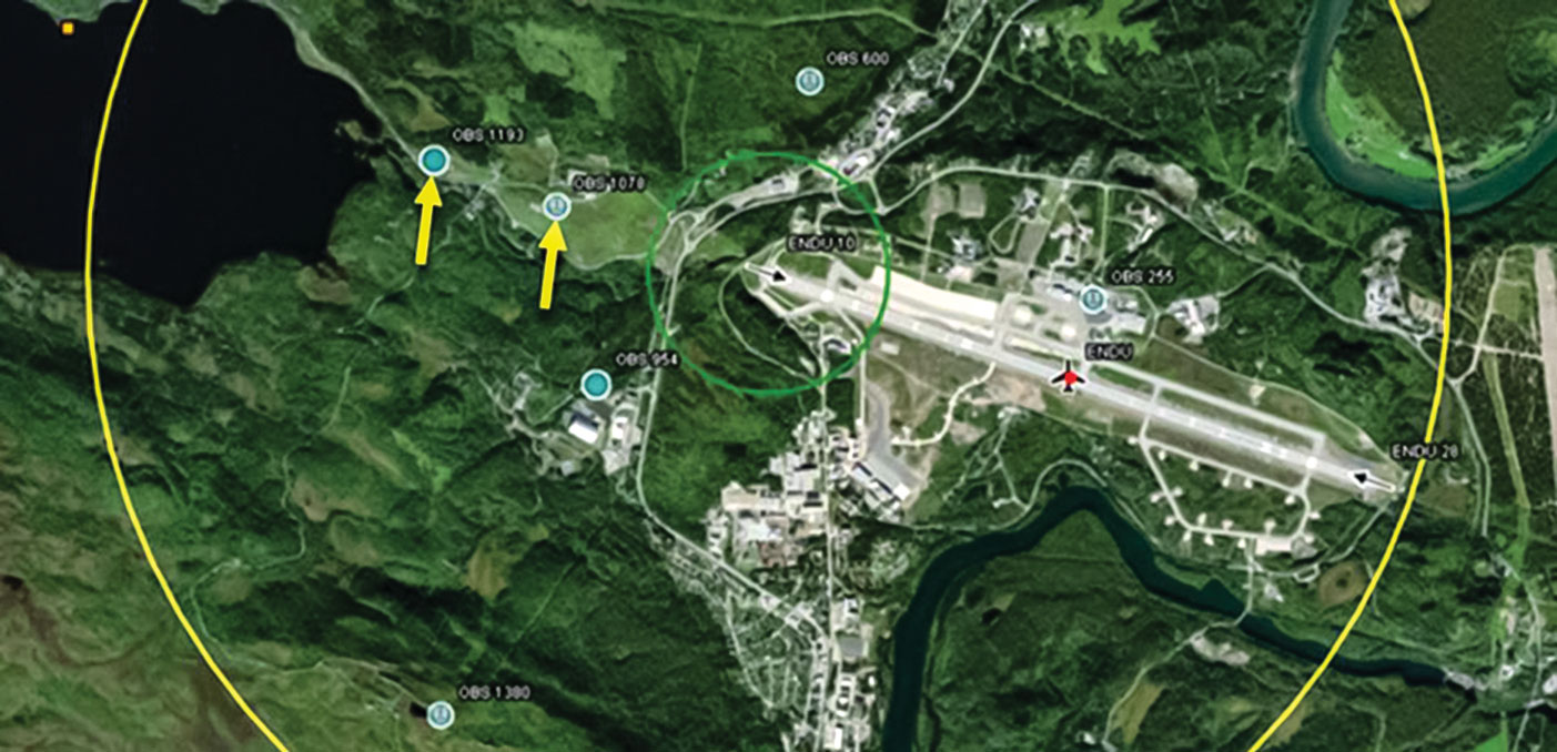
James Joyce, C-17 Military Flight Operations Quality Assurance (MFOQA) Flight Data Analyst, described what the warning system was seeing in his analysis. In Figure 1, he pointed out the location of two tall, erroneous obstacles inexplicably off the approach end of Runway 10 at Bardufoss Airport, and by analyzing past sorties into the airfield, saw that they had been causing nuisance alerts for years. Until Stewart and his crew wrote the ASAP, crews had not reported this false information.
Prior to their flight, Stewart and his crew were unaware that other crews had received nuisance warnings. Before going to an airfield, a document called the “giant report†is produced that has operational information for a particular location. The crew members are required to review it. If there are known anomalies with terrain or obstacles, they will be noted there; however, none were noted for this location, according to Stewart.
Writing an ASAP made a lot of sense for this situation. “It was immediately apparent that’s what we needed to do,†Stewart said. “I’m a huge fan of the ASAP program and attended an Ops RAMS [Operations Risk Assessment and Management System] program briefing at Scott [AFB] back in 2016.â€
He looks regularly to review new ASAPs when available and shares them with fellow 3d Airlift Squadron members. “The entire point of the program is to bring awareness to issues that might affect others and try to operate in the safest manner possible with all the information you can provide,†Stewart said. The ASAP Stewart and his crew wrote rectified an error that had been causing nuisance warnings for years, but now both towers are confirmed removed from the TAWS database.
It was the most in-depth ASAP to see what goes on behind the scenes after an ASAP is submitted,†Stewart said. “They took the information and ran and really dug in deep on it.â€
Once the aircraft had landed safely, Stewart and the crew wrote the ASAP first thing to make sure their information was accurate and concise. Stewart, who has written other ASAPs on his own, showed the other crew members the process of submitting an ASAP.
After submitting the ASAP with his contact information included, Mr. Tim Grosz, who leads the Ops RAMS branch, contacted Stewart to ask for more detail. He also asked maintenance for the flight data from the aircraft for analysis. After a thorough investigation, Mr. Grosz informed him that they had discovered other crews operating out of that airfield had received the same alerts, and that work was underway to have the obstacles removed from the database.
“It was the most in-depth ASAP to see what goes on behind the scenes after an ASAP is submitted,†Stewart said. “They took the information and ran and really dug in deep on it.â€
Joyce also stressed the importance of not only the ASAP program, but submitting TAWS/ground proximity warning system (GPWS) worksheets for incidents such as this.
“The TAWS/GPWS Nuisance Event Worksheet was created to provide crews an avenue to address the ‘imperfections’ that they discover concerning these two vital safety systems. Consequently, a major part of Ops RAMS’ effort to enhance crew confidence in their aircraft safety systems is to analyze every submitted worksheet,†Joyce said.
Although the TAWS/GPWS worksheet is for C-17s, he believes it is important for all flight crews to report incidents with similar safety systems. For this, the ASAP reporting is “a perfect tool†to have your concerns addressed by the Air Mobility Command staff.
The ASAP Stewart and his crew wrote rectified an error that, according to ASAP 14333, had been happening for years. The next approach to Norway’s Bardufoss Airport should thus prove less eventful, thanks to Stewart and his crew.
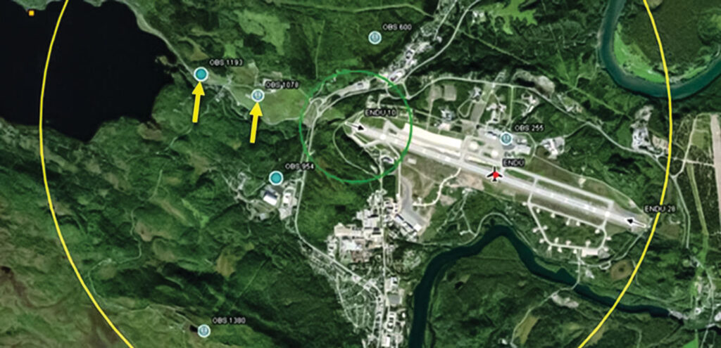
Figure 1. Two Erroneous Obstacles Causing Nuisance Alerts at Bardufoss Airport
Figure 1 shows the location of two tall erroneous obstacles (yellow arrows) inexplicably of the approach end of RWY 10 that have been causing nuisance alerts for years, which, until recently, crews were not reporting.
Figure 2. Aircraft Location When Warnings Sounded
Figure 2 shows an event at Bardufoss Airport that provoked the crew to report the nuisance warning that lasted 32 seconds until the aircraft itself (blue path) passed Obstacle 1078. After the team’s notifcation, the National Geospatial-Intelligence Agency (NGA) has since confrmed the obstructions no longer exist and will be removed from future databases.