Why the TAWS/GPWS Nuisance Event Worksheet Is So Important
By MR. JAMES JOYCE, C-17 MFOQA FLIGHT DATA ANALYST
The Operations Risk Assessment and Management System (Ops RAMS) branch in Air Mobility Command (AMC)/ A3 wants all crew members to have confidence in their warning systems, responding to system alerts in a timely and appropriate manner (as opposed to discounting them as invalid and nuisances) to prevent a controlled flight into terrain mishap from ever happening again. As we all know, aircraft safety systems are complicated, thus requiring continual improvements.
The Terrain Awareness and Warning System (TAWS)/Ground Proximity Warning System (GPWS) Nuisance Event Worksheet was created to provide crews an avenue to address the “imperfections†that they discover concerning these two vital safety systems. Consequently, a major part of Ops RAMS’ effort to enhance crew confidence in their aircraft safety systems is to analyze every submitted worksheet. Although this particular worksheet is a C-17 product, should not all crew members flying with similar safety systems report imperfections in their systems as well? If a similar process is not in place for your Mission Design Series, the Airman Safety Action Program (ASAP) reporting system is the perfect tool to use to express your concerns to AMC staff.
Occasionally, Ops RAMS’ analysis of nuisance worksheets shows that the TAWS and GPWS worked as designed, especially in hot, high-altitude, and heavy-weight situations in which the true airspeed is much higher than normal. Those conditions are typically not present during training, so crews often do not fully appreciate the rate of descent achieved when using the full flap idle/direct lift control techniques they practice in training; however, analysts often confirm actual nuisance events—for instance, a TAWS event at Yokota Air Base (AB).
Analysis of that event confirmed that the radar altimeter was erroneous because, during the bank, the device started bouncing its signal off the gear doors. Until a planned TAWS software upgrade is fielded, this “radar altimeter and gear door†issue will continue to result in a navigation solution error for the TAWS, which determines that the aircraft is not in a safe position to land (although it really is) and thus sounds the warning.
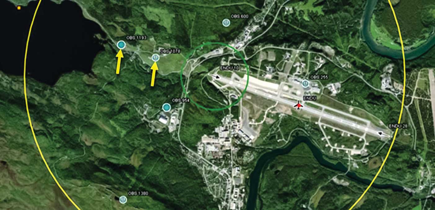
Following is another example of a TAWS event that was found to be a nuisance alert at Bardufoss Airport, Norway.
In Figure 1, yellow arrows point to the location of two tall erroneous obstacles inexplicably off the approach end of runway 10 that have been causing nuisance alerts for years, which, until recently, crews were not reporting.
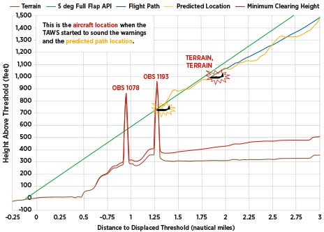
Figure 2 shows an event at Bardufoss Airport that provoked the crew to report the nuisance warning, which lasted 32 seconds until the aircraft (blue path) passed Obstacle 1078.
After the team’s notification, the National Geospatial-Intelligence Agency confirmed that the obstructions no longer exist and they were removed from the databases.
In addition, nuisance worksheet analysis has explored other unique terrain features, such as valleys and cliffs, on short final approach that will cause the GPWS to sound a false positive warning. After confirming locations with unique terrain features identified in TAWS/GPWS Nuisance Event Worksheets, Ops RAMS then performs additional in-depth analyses to provide precise distances and altitudes so crews know exactly where to anticipate the unique terrain warnings and can continue their approach if all appropriate conditions are met, as detailed in Air Force Instruction 11-2C-17v3 and the Airfield Suitability and Restrictions Report/ Giant Report list of GPWS-anomalous airfields. (Note: None of these airfield waivers are for TAWS warnings.)
Occasionally, C-17 pilots confuse the two terrain safety systems because they are so similar. The basic difference is that the TAWS, which relies on a terrain database and cannot be tricked by terrain anomalies, effectively looks ahead for obstacles and terrain, whereas GPWS Mode 2B simply looks down at the ground directly below the aircraft.
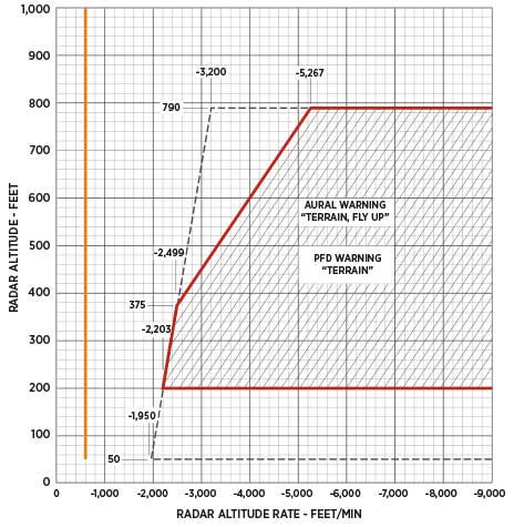
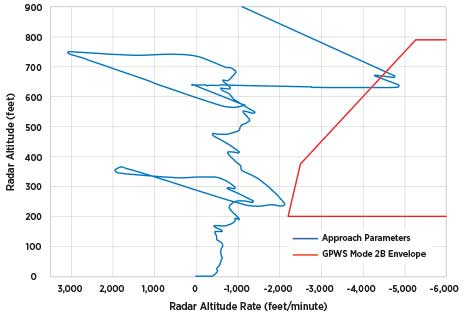
Although all C-17 pilots are familiar with the GPWS Mode 2B envelope (entry criteria shown in red for emphasis in Figure 3), they do not typically see where their flight paths would place them on the chart. If an aircraft were flying over the dry lake bed at Edwards Air Force Base, with its flat terrain, maintaining a steady 600 fpm descent, the flight path would be depicted by the very straight orange line down to the 50’ power push. Most runways have varying terrain on final, however, so the radar altitude paths are much more dynamic.
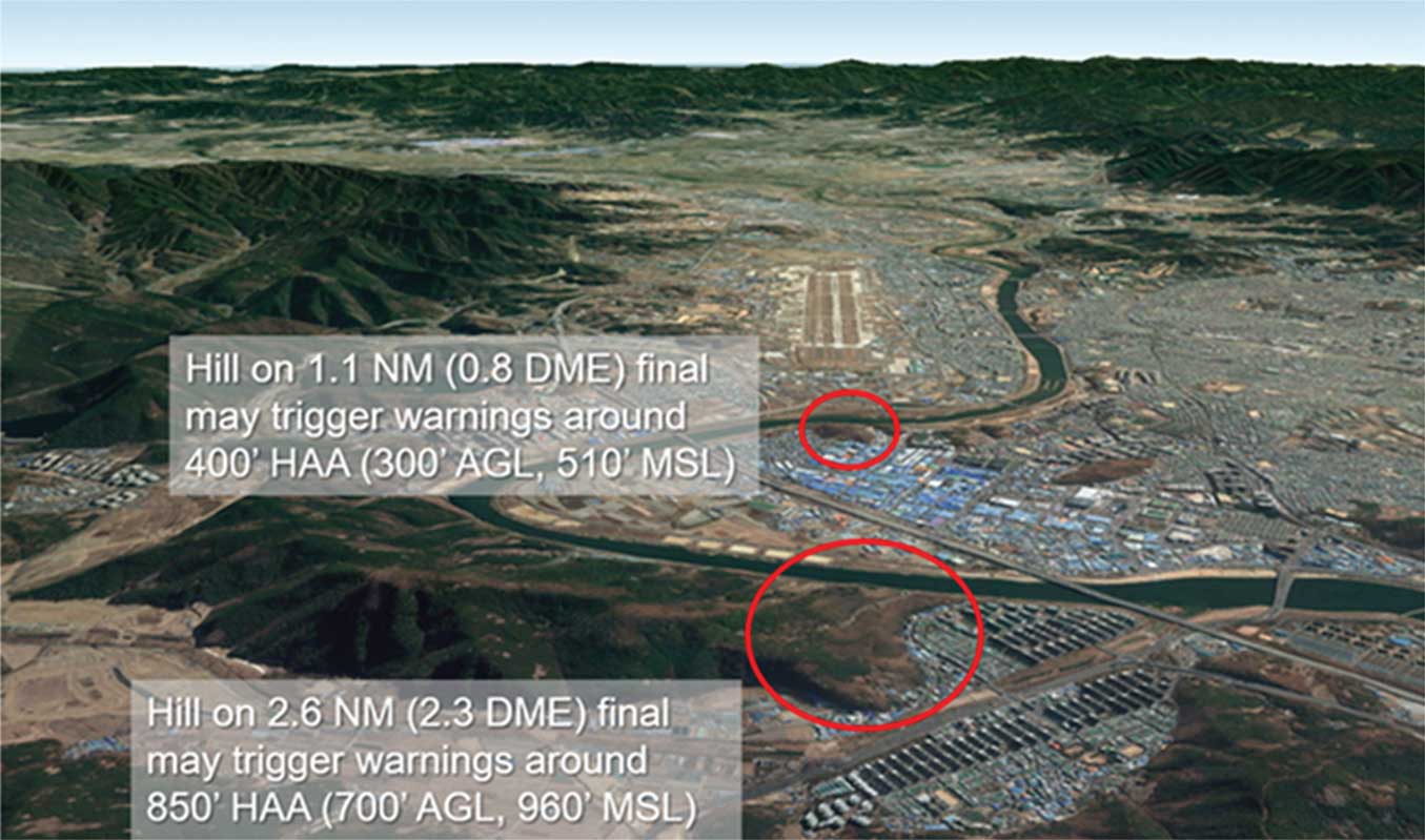
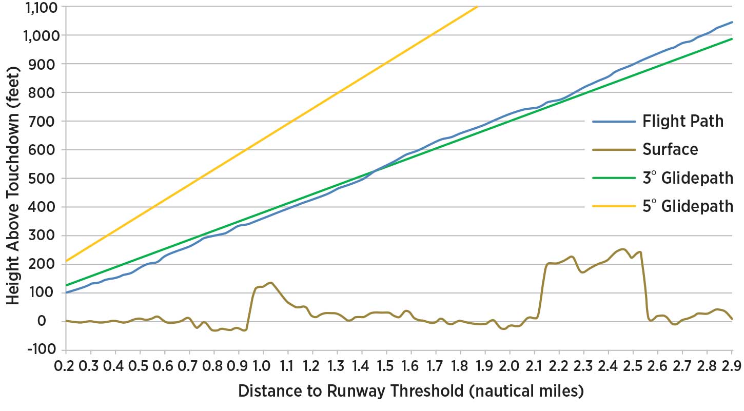
With this understanding of how GPWS Mode 2B works, the following example of Military Flight Operations Quality Assurance (MFOQA) analysis addressed crew-reported nuisance alerts at Daegu AB, South Korea. The analysis results allowed Ops RAMS to support, as crews had requested, adding Daegu AB to the list of airfields with special procedures to disregard GPWS warnings at night or in instrument meteorological conditions if GPWS warnings occurred over either of the two hills circled in Figure 4.
Several approaches were plotted by the MFOQA analyst in the verification process; the one in Figure 5 was chosen for this article because it highlights how variable these warnings can be. The blue path shows how the crew was slightly above the green 3-degree glide path while crossing the 2.6 nautical mile (nm) hill and was then slightly below the glide path crossing the 1.1 nm hill.
Figure 6 shows that the “Terrain, Fly Up†envelope was penetrated as the aircraft crossed the first hill between 600’ and 700’ above ground level (AGL), but the radar altitude rate did not quite reach the red line between 200’ and 300’ AGL as the aircraft crossed the second hill. Flying the aircraft to the left or right parallel runway affects the likelihood of receiving a warning, as well, due to hill slope variabilities.
The bottom line is, if you receive a TAWS or GPWS warning that you do not think is legitimate, please fill out a TAWS/GPWS Nuisance Event Worksheet. By doing so, you are helping to improve the safety of the fleet and increase crew force trust in these vital safety systems. If you have never heard of or filled out this worksheet, have your favorite instructor pilot show you where to find it and fully explain its purpose. Whenever you fill out the worksheet, please take photos of the Mission Computer Display pages for each event at the completion of your sortie, send them to Stan/Eval, and ask Maintenance to harvest the flight data from the recorder as soon as practicable by making an Air Force Technical Order Form 781A entry.